


Meteorologists are keeping a close eye on the tropical Pacific Ocean, where warming sea surface temperatures indicate an El Niño event is likely developing, saying that there is a 62% chance that El Niño thresholds will be met by the late spring or early summer. NOAA reports that while the current El Niño event has peaked, its effects on temperatures and precipitation may persist through April.
So what exactly is El Niño? It’s a naturally occurring climate pattern linked to periodic warming of sea surface temperatures in the equatorial Pacific Ocean. This impacts weather patterns worldwide, particularly during North America’s spring and winter seasons.
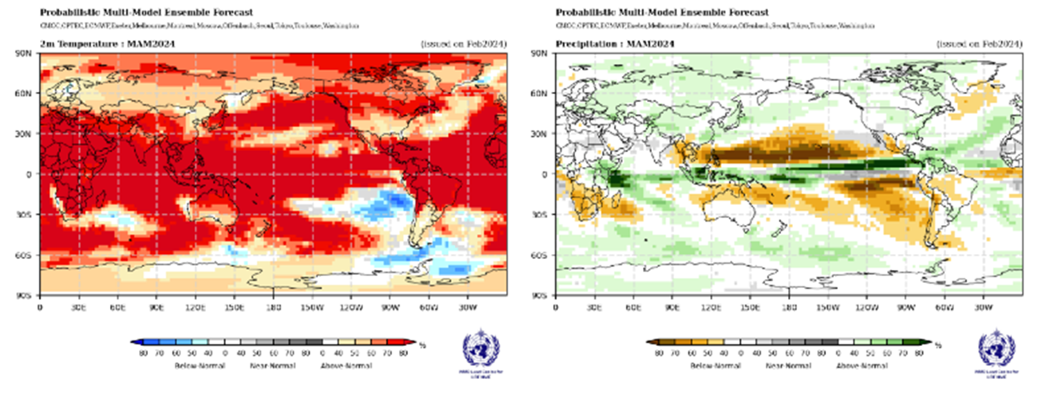
The World Meteorological Organization recently examined this in depth with several interesting findings. During December 2023-February 2024, sea-surface temperatures in the eastern Pacific (Niño 1+2) and central Pacific were above normal but declined. This suggests an El Niño state in the equatorial Pacific, along with above-normal temperatures in the Indian Ocean and tropical Atlantic. Sea-surface temperature anomalies in the Niño 3.4 and Niño 3 regions, currently above normal, are expected to decrease during April-June 2024, transitioning to ENSO-neutral conditions.
Temperature and Precipitation
For April through June, it is probable that above-average temperatures will continue across much of the U.S. The Great Lakes region, the Pacific Northwest, and Northwest Alaska have the highest likelihood of experiencing above-average temperatures, although most of the continental U.S. and Alaska are expected to have elevated odds of warmer-than-usual conditions.
In terms of precipitation, there is a slight inclination towards above-average rainfall in portions of the central Plains, the southeastern U.S., and southern Alaska. Conversely, areas in the Pacific Northwest and Southwest are more likely to see below-average precipitation during this period.
A Cooler and Wetter Spring for the South and a Drier Spring for the Northwest and Ohio Valley
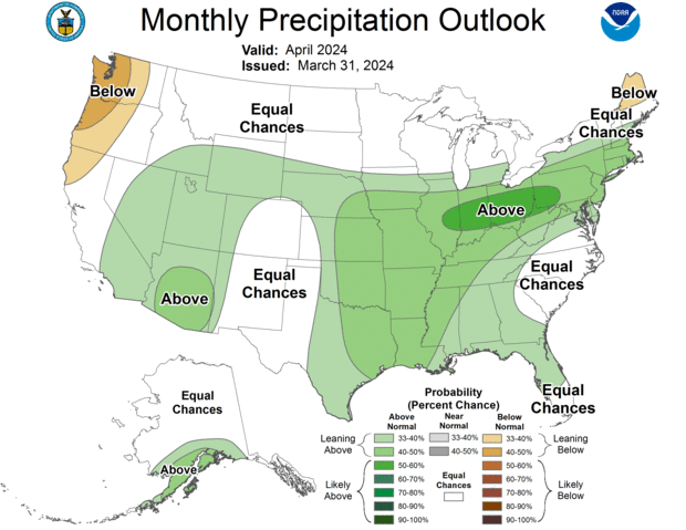
The potential for below-normal temperatures extends across the Southern Plains, Southeast and into the Mid-Atlantic region. Wetter than normal conditions are favored across the South as well.
On the flip side, the Northwest and parts of the Ohio Valley may experience drier than normal conditions if El Niño arrives, according to the outlook.
Delayed End to Winter in the Northern U.S.
El Niño springs tend to keep winter weather patterns more entrenched across the northern tier of the United States. The precipitation forecast indicates a strong likelihood of well-above-average precipitation (rain and/or snow) in significant portions of the western, central, and eastern regions of the country. Conversely, below-average precipitation is expected only in parts of the Pacific Northwest and northern Maine.
Certainly, long-range forecasts can be challenging, particularly during transitional seasons. However, the team at Weather Source is always monitoring conditions by utilizing the most reliable and best-in-class resources available.
Weather Source not only offers forecast views up to 46 days, but we also offer seasonal forecasts in monthly views out up to seven months. Talk to us to learn more and how your business may be impacted by spring weather and beyond.