


The summer of 2024 has been anything but ordinary in the weather world. With a series of remarkable weather events capturing attention, this season has kept experts and enthusiasts alike engaged.
A storm hit the West Coast at the end of August, bringing snow to California’s mountains and the Pacific Northwest. This led to the closure of a highway in Lassen Volcanic National Park after three inches of snow fell. Simultaneously, a flash flood watch was issued for the burn scar of California’s largest wildfire this year.
From record-breaking temperatures to unusual storm patterns, let’s explore the key events that have defined this summer’s weather landscape.
Summer Heat
This summer has shattered records nationwide, with over 30 U.S. cities, from the East Coast to California and the Southwest, experiencing record-high temperatures in the first half alone. It’s hard to believe that meteorological summer – June through August, typically the hottest time in the Northern Hemisphere – is coming to an end.
For example, Phoenix surpassed its previous record for the hottest first six weeks of summer by nearly three degrees, according to the SERCC and Las Vegas hit 120 degrees for the first time, surpassing its previous half-summer record from 2021 and full-summer record from 2018.
Even more than a dozen cities in the East either matched or broke their record for the hottest summer by mid-July, according to the Southeast Regional Climate Center and New Orleans is on track to have one of its hottest summers on record, and “feels like” temps of 100+ are likely to continue into September, the National Weather Service says.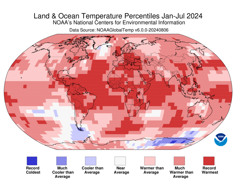
And it’s not over yet, according to NOAA, “September-October-November (SON) temperature outlook favors above-normal temperatures across a majority of the contiguous U.S. with the largest probabilities (exceeding 60%) forecast for New England and parts of the Southwest. Increased below-normal temperature probabilities are forecast for southwestern Alaska, while above-normal temperatures are more likely across northern Alaska”.
The Hurricane Threat
So far, the season has been near or above average, with five named storms, three hurricanes, and one major hurricane.
With that said, NOAA revised its seasonal forecast in early August, predicting 17 to 24 named storms this year, including 8 to 13 hurricanes. This exceeds the average year, which typically sees 14 named storms with seven reaching hurricane strength. And remember, hurricane season runs through November 30.
“The hurricane season got off to an early and violent start with Hurricane Beryl, the earliest category-5 Atlantic hurricane on record,” said NOAA Administrator Rick Spinrad, Ph.D. “NOAA’s update to the hurricane seasonal outlook is an important reminder that the peak of hurricane season is right around the corner, when historically the most significant impacts from hurricanes and tropical storms tend to occur.”
In mid-June, Tropical Storm Alberto drenched parts of Texas and New Mexico with nearly a foot of rain, causing flash floods. Hurricane Beryl followed on July 1, setting a record as the earliest Category 5 storm in the Atlantic. Beryl’s devastating path through the Caribbean islands resulted in about 20 deaths, while its impact on Texas, Louisiana, and Vermont led to approximately 25 more fatalities.
“Hurricane Beryl broke multiple long-standing records in the Atlantic basin, and we’re continuing to see the climatological hallmarks of an active season,” said Matthew Rosencrans, lead hurricane season forecaster with NOAA’s Climate Prediction Center.
The latest big storm, Debby, struck Florida’s Big Bend, causing a life-threatening storm surge, widespread flash floods, extensive power outages, and multiple tornadoes. Over its week-long impact on the eastern U.S., the storm caused over a billion dollars in damage and resulted in at least nine fatalities. Thankfully Ernesto, which briefly hit Category 2 status, stayed out in the Atlantic after making a brief stop in Bermuda.
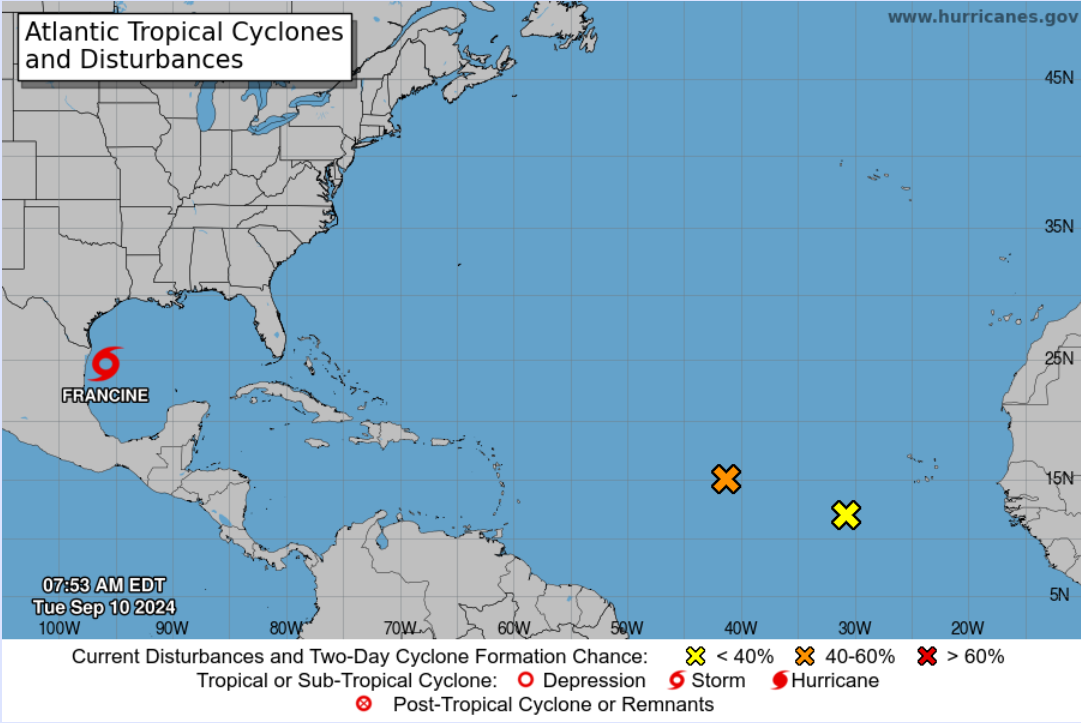
Currently there are three storms being tracked in the Atlantic, including Francine, and many experts aren’t closing the door on the season yet. The National Hurricane Center is closely watching a tropical wave in the mid-Atlantic, with long-range models suggesting it could develop and move toward the Caribbean this weekend or early next week. Its southerly track might help it avoid the Saharan dust that often stifles tropical systems.
Wildfires
This summer has been no stranger to wildfires, once again. So far this year, over 36,040 wildfires have scorched more than 6,918,822 acres across the United States, according to the National Interagency Fire Center.
Perhaps the most life-threatening Nevada fire so far of 2024 was the nearly 700-acre Gold Ranch Fire that could have burned hundreds of homes near Verdi, a small town in Washoe County. Then there is California’s Park Fire, the state’s fourth-largest fire ever recorded. The Park Fire, in Lassen National Forest and areas of Butte and Tehama counties, has scorched over 429,460 acres
The National Interagency Fire Center states that late summer and fall are characterized by extremely dry fuels in many parts of the country, and several geographic areas continue to fight fires that threaten homes and present major challenges to containment. Even if temperatures are coming down in your area, maintain heightened awareness of any possible sources of ignition.
Hot and dry conditions will continue in much of Tennessee, northern Alabama, and northern Mississippi, with minimum relative humidity of 15-30%. Moisture will slowly move north into central Mississippi and central Alabama, with isolated to scattered afternoon thunderstorms that could result in lightning ignitions.
At Weather Source, we provide powerful tools that empower businesses to confidently prepare for hurricanes and other severe weather. Our comprehensive suite of services equips you with crucial weather insights, keeping you informed and ready to tackle extreme weather events.
Connect with us to discover how we can help you stay ahead of the storm!