
OnPoint® Weather is described exactly as it sounds, weather data for any location at any point in time. Weather Source ingests all available weather inputs, unifies them under our intelligent code, and resolves issues related to geography, topography, and elevation to deliver accurate predictions at any point on Earth.
The OnPoint Weather dataset is a curated continuum of historical data from the year 2000 to present, current data, and forecast data of up to 15 days with an enhanced view out to 46 days. Weather Source also offers historical forecast data back to January 2015.
Unlike most weather data providers, who simply extend information to your location, Weather Source reveals weather and climate insights tailored to your precise business locations.
Many of our competitors rely solely on data from airport observation stations, a method that is flawed for several reasons:
- Airport observation stations are often too far—up to hundreds of miles—from your location to provide meaningful insight.
- Up to 25% of airport observation stations routinely report gaps and errors in their data.
- A meteorological background or significant experience working with weather sensor data is required to decode and prepare airport observation station data for analytics and modeling.
- Many airport observation stations are located adjacent to an urban center or a large body of water, which can directly affect reported weather. For example, Boston’s Logan International Airport is at sea level, subject to onshore ocean breezes, and located next to a significant urban center, meaning its weather is often markedly different from that at locations less than 1 mile away.
Weather Source begins with your lat/lon coordinates or specified geographically bounded areas such as:
- Census tract/block
- County/parish or state
- Designated Market Area (DMA)
- ZIP/Postal Code
We then map data to our high-resolution OnPoint Grid using a variety of inputs:
- Airport observation stations
- NOAA & NWS data
- Satellites
- Radar
- Weather analyses and model outputs
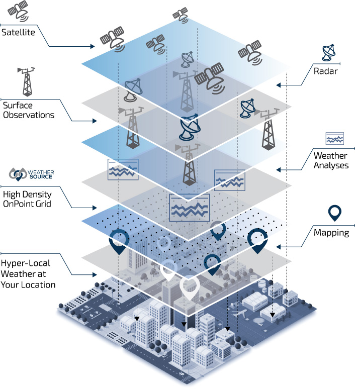
The globally consistent, 5-kilometer OnPoint Grid covers every land mass in the world and up to 200 miles offshore. Each grid point—millions in total—represents a “virtual” weather station with a unique OnPoint ID from which weather data can be mapped. This unparalleled method ensures your North American location of interest is never more than 2.2 miles away from an OnPoint ID—as opposed to potentially hundreds of miles away from the nearest airport observation station.
Weather Source supports all weather parameters, including:
- Cloud cover
- Humidity
- Precipitation
- Solar radiation
- Surface pressure
- Temperature
- Wet & dry bulb
- Wind speed
Temporal: Hourly or daily resolution
Format: Tabular or geospatial
Delivery Methods:
- CSV files
- FTP, SFTP & FTPS
- The OnPoint API
- All major business intelligence platforms
A logistics company with tight delivery deadlines used OnPoint Weather and our solution suite to perform regression analysis and identify weather conditions that result in delivery delays. Weather Source then created a model for the company to monitor for similar conditions, empowering them to adjust routes and schedules to prevent future setbacks.
A global pharmaceutical company used OnPoint data to create an influenza forecast. After identifying which weather parameters (temperature, humidity, and precipitation) resulted in higher rates of the flu, Weather Source created a predictive model to forecast spikes within requested geographic locations. This analysis also included social media, internet search, and government data. The predictive model gives the customer a competitive edge, ensuring they have sufficient marketing and inventory resources in the right locations at the right time.
A large automobile manufacturer uses OnPoint Weather to quantify the impact of weather on all aspects of its operations, including logistics, supply chain, facility heating and cooling costs, employee absenteeism, site selection, and more.
A significant hedge fund with a position in agricultural commodities uses Weather Source data to monitor evolving temperature and precipitation anomaly trends as well as forecasted anomaly trends. This empowers the fund to quantify the impact on commodity futures and optimize its trading positions.